
MIDDLE KALIGANDAKI HEP
Middle Kaligandaki Hydroelectric Project (MKHEP) is located in Myagdi district of the Gandaki Province of Nepal. The project components of MKHEP are located in Annapurna Rural Municipality. The project lies between the project boundary of 83° 38′ 00” E to 83° 40′ 00” E and 28°28′ 56” N to 28°31′ 32” N. Both the headworks and powerhouse components are located in Annapurna Rural Municipality. The project is of run-off river type. The power generating flow is diverted by constructing a free-flow sloping glacis-type concrete gravity weir with the gated dam located just downstream of the tailrace of Tatopani Small Hydro Project near village Suke Bagar and the flow is guided to the underground powerhouse through about 4883m long waterway comprising approach canal, settling basin, power culvert, headrace tunnel, vertical drop-shaft and horizontal penstock pipe.
| The district headquarter, Beni is accessible with vehicles over a blacktopped road of 290 km from Kathmandu via Prithvi Highway. The headworks located in Dana is about 25 km earthen road from Beni Bazar via the Pokhara-Jomsom highway. Also, from Kathmandu. Middle Kaligandaki Hydroelectric Project is connected by the vehicular road but still is under regular maintenance. The proposed diversion site is located on Kaligandaki River just downstream of the tailrace of Tatopani Small Hydro Project near the village Suke Bagar with its coordinates 28°31’14’’N & 83°40’E. The powerhouse site is located downstream of the confluence of Ghar Khola with Kaligandaki river in Annapurna Rural Municipality with its coordinates 28°28’56” N & 83°38’52” E. The diversion and powerhouse sites are approachable through Pokhara-Jomsom highway. A 30 km stretch from Beni to Dana (headworks area of the project) needs to be improved for the movement of mechanized equipment and transport of heavy electro-mechanical equipment. | 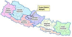 |
|
Location
Type of Project => Run-of-River (RoR) Rural Municipality => Annapurna Rural Municipality District => Myagdi Project => Kaligandaki River => Gandaki Preject Area => East Lat. 28°28’56” N to 28°31’32” N Northing Long. 83°38’00” E to 83°40’00” E |
Hydrology Catchment Area => 3638.4 km² Design Discharge (40% exceedance flow) => 52.85 m³/s Long-term annual average flow => 98.62 m³/s Design flood at intake (1 to 100 years) => 1285.63 m³/s Design flood at tailrace (1 to 100 years) => 1493.07 m³/s |
Power and Energy With Design discharge (Q40) =>52.85 m³/s Rated net head => 140.22 m Capacity => 66.3 mW Dry Energy => 130.21 (31.99%) GWh Wet Energy => 276.86 (68.01) GWh Annual total Energy => 407.20 GWh |